Clonaslee Looped Walks

Clonaslee is a village in north County Laois, situated in the foothills of the Slieve Bloom Mountains on the R422 Mountmellick to Birr road. The name means “meadow of the way”, the way referred to was once a very important cross-country route across Laois leading onto Munster. It is an excellent hub for walking with access to the Slieve Bloom Way, Brittas Lake and also to a number of shorter looped walks.

Link to Rickets Rock Loop Map of Rickets Rock loop
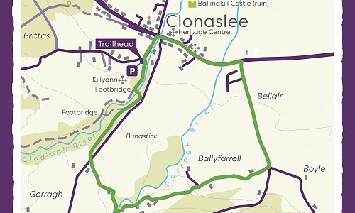
Distance: 4.5km / 1hr - 1.5hrs
Trail Grade: Moderate

Rickets Rock Loop

To suit: All levels of fitness
Terrain: Mix of minor roads, sandy roadways & forestry tracks
Link to Brittas Lake Loop Map of clonaslee brittas
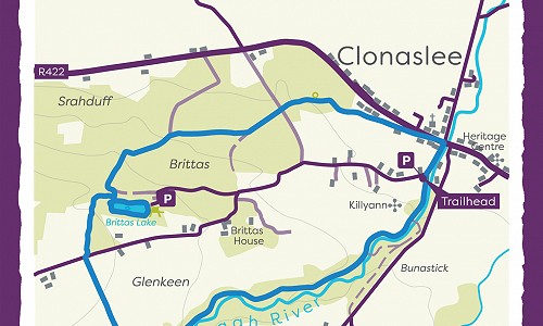
Distance: 6km / 2 hours 30mins
Trail Grade: Moderate

Brittas Lake Loop

To suit: Medium level of fitness
Terrain: Forestry road, tracks
Link to Glendineoregan Loop Map of glendineoregan loop walk
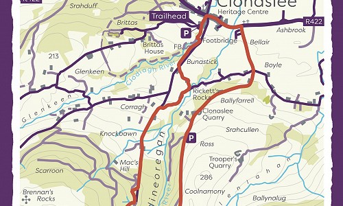
Distance: 11.7km / 2-3hrs
Trail Grade: Strenuous

Glendineoregan Loop

To suit: Higher than average levels of fitness
Terrain: Mix of minor roads, sandy paths & woodland trails

Directions to Trailhead

LocationBrittas Forest Recreation Area, Clonaslee Garda Station, Main St, Brittas, Clonaslee, Co. Laois

From the bridge over the Clodiagh River in the village of Clonaslee (on the R422) follow the signpost for Glenkeen. The forest entrance is on your left after 200m.

Clonaslee is at the northern gateway to the Slieve Bloom Mountains. A picturesque village, founded in the 18th century, here lies the traditional seat of the O’Dunnes. Clonaslee lies on the famous Slí Dála or Munster Way.


Walking Calendar

The Slieve Bloom Walking Club organise walks every weekend of the year. All of these walks are led by an experienced and friendly walk leader who is very familiar with the mountains. These walks are post to the Walking calendar weekly.

Join Weekly Walk

A panel of guides are also available if you are are looking for a personal leader who can tailor-make a walk to suit your party or group.